You are here
Fani Maoré, the submarine volcano that shook Mayotte
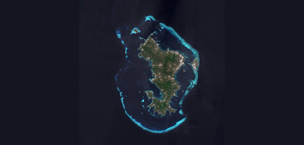
On 10 May, 2018, Mayotte was hit by the first of a series of earth tremors. For several months, dozens and sometimes hundreds of quakes were recorded each day, causing rising panic among the population. On 15 May, the seismic activity reached a peak when an earthquake with a magnitude of 5.9 on the Richter scale damaged a number of buildings. Many residents decided to spend the night outdoors, camping out in stadiums and other open areas. They were all the more anxious that in living memory, this French island, located to the north-west of Madagascar, had never before faced such an event.
Unexpected quakes
Scientists were just as flummoxed. “If someone had told us, before then, that Mayotte would be hit by a magnitude 5.9 earthquake, we would have found it hard to believe,” admits Aline Peltier, a volcanologist at the IPGP1 and head of the Piton de la Fournaise volcano observatory OVPF on Réunion Island, also in the Indian Ocean. This is scarcely surprising since Mayotte was not thought to be in a high seismic risk zone. “The area hadn't been studied to any significant extent as there wasn't much going on there,” recalls Éric Humler, chair of the CNRS's Very Large-Scale Research Facilities Committee (TGIR).
“Back then, we didn't know whether the earthquakes were volcanic or tectonic in origin,” explains Vincent Famin, a researcher at the GeoSciences Réunion2 laboratory. “However, there was a significant difference between the two. If the origin was volcanic, more powerful earthquakes were unlikely to occur. Whereas if it was tectonic, any magnitude was possible.” Scientists quickly swung into action. Major research organisations, including the CNRS and eight French universities,3 joined forces and, with government backing, succeeded in record time in putting together a research campaign and setting up measuring instruments. Their primary objectives were to identify the cause of the quakes and evaluate the risk to the population of Mayotte and the Comoros.
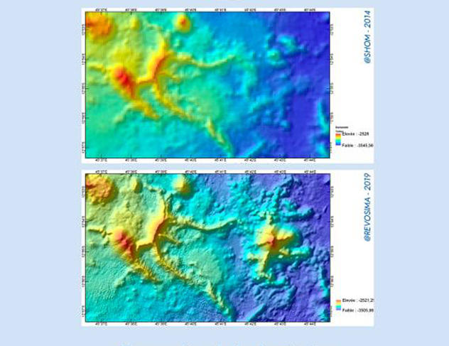
Almost four years after the launch of this research programme, an initial assessment can now be made. Not only have the researchers found the source of the earthquakes, but their work has profoundly transformed the picture that geoscientists had of the Comoros. For example, Mayotte, far from being the peaceful, sleepy island it was once thought to be, has turned out to be a major site of volcanic activity. These findings led to the establishment of the Mayotte Volcanological and Seismological Monitoring Network (REVOSIMA) operated by the IPGP and its partners, with a real-time monitoring facility based at the Piton de la Fournaise volcano observatory that is operational 24 hours a day. The scientific journal Comptes Rendus Géoscience has recently published a special issue (in English) that reports on the new intelligence acquired during this remarkable scientific endeavour.
Discovery of a hyperactive giant
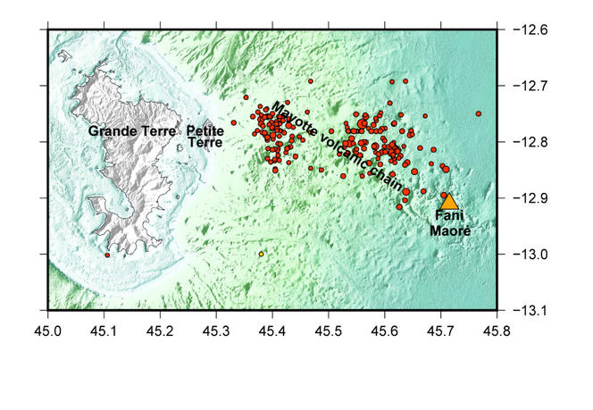
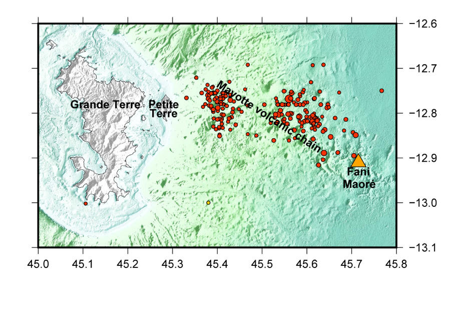
In May 2019, just one year after the first earthquake swarm, a scientific team set sail from Mayotte aboard the oceanographic research vessel Marion Dufresne, as part of the MAYOBS 1 survey. They headed east, towards the region where the seismographs on the island had placed the epicentre of the quakes, and where local fishermen said they had smelt unusual odours and seen deep-sea fish floating on the surface.
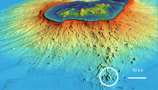

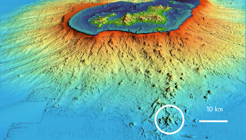
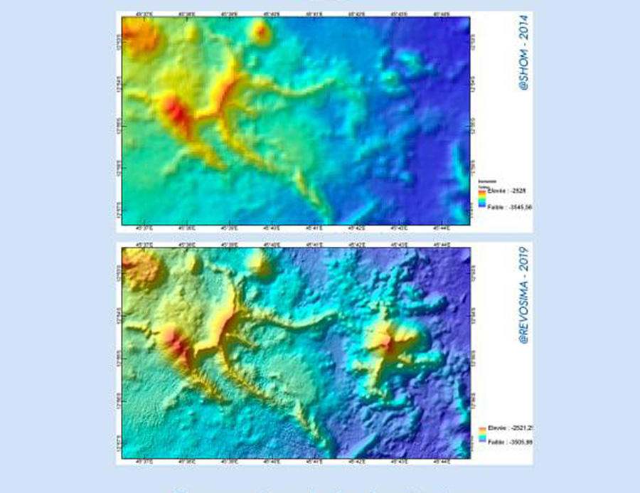
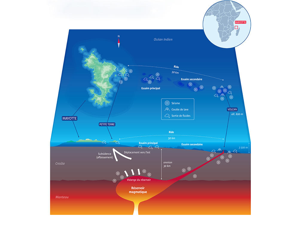
The researchers finally discovered the source of the earthquakes some 50 kilometres from the island. At a depth of 3,500 metres, a submarine volcano was in an intense state of activity, spewing out as much as 400 cubic metres of lava per second. In just a few months, Fani Maoré, as it was subsequently dubbed, had produced a cone 800 metres high and 2 kilometres in diameter. During the eruption, which lasted three years, it ejected no less than 6 cubic kilometres of lava. “This is the largest effusive eruption known since that of Laki, in Iceland, in 1783,” Peltier points out.
The scientists had found the culprit at last. The Mayotte earthquakes were clearly linked to the frantic activity of this underwater giant. Two mechanisms can explain them. “The first tremors, in May 2018, were produced by magma upwelling through fractures in the Earth's crust. The magma under pressure surged upwards towards the ocean surface, breaking through the rock on the way. The following tremors, from August 2018 on, were probably caused by the collapse of the magma chamber after it had been drained of its lava to feed the volcano,” explains Jérôme Van der Woerd, a researcher at the ITES.4
The research team was surprised that the earthquakes originated between 30 and 50 kilometres below the surface. This meant that Fani Maoré's magma chambers and conduits were located in the Earth's mantle at an unusually great depth. The amounts of magma involved were so huge that, during the underwater eruption, the island of Mayotte shifted 24 centimetres eastwards and subsided by 19 centimetres.

Volcanoes by the hundreds
Yet the discovery of the volcano did not signal the end of the scientific mission. The researchers were only too aware that they were caught off guard by the 2018 tremors because their knowledge of the region was incomplete. To fill these gaps, and also to monitor Fani Maoré's activity, thirty oceanographic campaigns were carried out over the following three years.
One of the most ambitious was dubbed the Sismaoré mission. “Its goal was to broaden the scope of our research by studying volcanic activity over the whole Comoros region,” Famin explains. And it held plenty of surprises in store. Bathymetric surveys revealed the existence not of dozens, but of hundreds of submarine volcanoes forming a previously unknown volcanic province extending along a corridor 600 kilometres long and 200 kilometres wide. The researchers seized the opportunity to collect rock and core samples in order to find out more about the age and formation of this multitude of volcanoes. “The results are being analysed,” says Van der Woerd. But the scientists have already dated some volcanic deposits on the islands of Moheli and Anjouan to 8,000 and 9,000 years ago.
Rather than being limited to a single active volcano, Kartala, the Comoros turned out to be home to sustained activity, much of which in extensive areas under water. The researchers thus came to the obvious conclusion that the plate tectonics and the entire history of the formation of the Comoros had to be completely re-examined.
It had long been believed that the archipelago was located right in the middle of the Somali Plate, which as it moved away from Africa, led to the opening of the famous East African Rift. The genesis of the Comoros was thought to be due to a hot spot, upwelling plumes of magma fed by the underlying mantle that melt through the Earth's crust, leading to the emergence of island chains such as the Hawaiian Islands or the Azores.
This theory, already challenged in 2018, collapsed with the eruption of Fani Maoré and the research campaigns that followed. Researchers now believe that the archipelago actually lies on a weak zone of oceanic crust that forms a diffuse boundary between the Somali Plate and a second, smaller one called the Lwandle Plate. According to Famin, these two plates are sliding past each other in opposite directions, causing magma to rise. “Volcanism in the Comoros is plate-boundary volcanism,” he says. “We believe that this volcanic region is in fact a continuation of the East African Rift that then extends towards Madagascar. To confirm this, we need to date and analyse the rocks we collected.”
As always, new discoveries raise fresh questions. “We still have to reconstruct the history of volcanism in the region. We also need to determine the relative motion of the two plates and see whether it has changed over time,” Van Der Woerd adds.
A closely monitored island
During the MAYOBS 1 mission the researchers made another finding that was just as unexpected. Underwater images revealed significant upwelling of gas from the ocean floor in an area called the Fer à Cheval, some ten kilometres from Mayotte. Has this upwelling always existed? Is it a sign of degassing from magma deep beneath this structure? Does it herald a fresh eruption? “No scenario can be ruled out. What we do know is that, between the MAYOBS 1 and MAYOBS 23 oceanographic campaigns, their number steadily increased. In any case, if there was a new eruption nearer Mayotte, it could be dangerous for the population,” Peltier warns.
Van Der Woerd also expresses concern: “No one can say for certain what's going to happen. The only comforting thought is that volcanoes always give warning signs.” True enough, every eruption is preceded by precursor activity. But experts have to be on their toes, which is why the REVOSIMA was set up. The network is operated by the IPGP and the French Geological Survey (BRGM) and is the result of a collaboration between some thirty research organisations, including the CNRS, as well as universities and French Government ministries.
Mayotte now has eleven permanent seismic stations and nine geodetic markers, GPS reference points that are used to continuously keep track of the deformation and movement of the Earth's surface. Another station measures gas ebullition sites, where gases are released from the Earth’s interior. All this data arrives in real time at the Piton de la Fournaise volcano observatory, which monitors the area 24 hours a day.
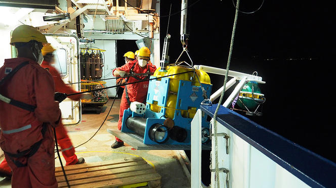


And that's not all. Seafloor seismometers have been deployed near Fani Maoré and at the Fer à Cheval, and their records are collected during each oceanographic campaign. Two autonomous underwater gliders constantly check the plume zone. And finally, an underwater station called MARMOR5 is in the pipeline. Located at the Fer à Cheval, it will be managed by IFREMER and will carry out continuous measurements of seismo-volcanic activity and associated phenomena such as plumes.
“Every morning I receive the REVOSIMA bulletin by email. It tells me whether there has been any seismic activity in Mayotte. If so, it indicates the quake's magnitude, as well as its location and the depth of the source,” says Humler, one of the key players in the scientific response to the 2018 earthquake event. “The REVOSIMA is a nice example of how different disciplines can be integrated. It provides a model for how best to respond to a crisis, one that can be used elsewhere, in places such as the French West Indies, where there is also underwater volcanic and tectonic activity.” In any case, one thing is certain: should another seismic or volcanic episode strike Mayotte, scientists will be standing at the ready.
Reference: “The Mayotte seismo-volcanic crisis of 2018-2021 in the Comoros archipelago (Mozambique channel)”, Jérôme Van der Woerd, Vincent Famin and Éric Humler (Eds.), Comptes rendus Géoscience, volume 354, n° S2, 2022.
- 1. Institut de Physique du Globe (CNRS / IPGP).
- 2. Research unit at the IPGP.
- 3. CNRS, IPGP, BRGM, IFREMER, CNES, IGN, Service Hydrographique et Océanographique de la Marine (SHOM) and eight universities (Paris, Strasbourg, Grenoble Alpes, Clermont Auvergne, Réunion, Toulouse III - Paul Sabatier, Bretagne Occidentale and La Rochelle).
- 4. Institut Terre et Environnement de Strasbourg (CNRS / Université de Strasbourg).
- 5. Marine Advanced geophysical Research equipment and Mayotte multidisciplinary Observatory for research and Response.


