
Windows to a dream world
You are here
 Lire en français [2]
Windows to a dream world
09.25.2026, by
Virtual globes, 2D or 3D representations of the world produced from digital data, can fool us into thinking that we now know everything there is to know about the Earth. But a deluge of data is no guarantee of a better picture of “reality”.

1
Slideshow mode
Virtual globes generate images of our planet that help shape the way we perceive the world. However, just as the map is not the territory, virtual globes wrapped in digital data are not the world, as shown by the researchers and artists involved in the Spherographia project. It is therefore well worth studying these globes in order to understand exactly why they are produced and to move beyond the mindset that the philosopher Michel de Certeau described as the “totalising eye”. For example, in the iconic “Blue Marble” image of the Earth, taken in 1972 during the Apollo 17 mission, the South Pole is located at the top, with the African continent in the centre (left-hand image). This photograph is frequently inverted so that the North Pole, in accordance with Western cartographic conventions, appears at the top (right-hand image).
NASA /USRA – Lunar & Planetary Institut (L);Image courtesy of the Earth Science and Remote Sensing Unit, NASA Johnson Space Center (R)

2
Slideshow mode
The “Erdapfel” created by the German explorer and geographer Martin Behaim, is the oldest known terrestrial globe, dating from 1492. It is currently kept in Nuremberg, Germany. A milestone in the history of cartography, it reflects Europeans' geographical understanding of the world in the late 15th century, prior to the Age of Discovery. The Americas are missing, while the oceans are populated by mythical creatures. The authors' desire to fill in the blank spaces on the maps by combining cartographic fantasies, textual descriptions and artistic illustrations is already evident. ––– EXPLORE THIS GLOBE IN AUGMENTED REALITY: Scan the QR Code with your phone's camera, then point it at the marker just below it.
Martin Behaim's Erdapfel, 1492. (Facsimile of Behaim's Globe) / David Rumsey Historical Map Collection (globe interactif, Google Earth)

3
Slideshow mode
Many historians have emphasised the key role of globes in the symbolic assertion of power over the world. Observations by geographers and astronomers gradually led to a clearer understanding of the spherical nature of our planet, enabling it to be depicted as such. Symbolising the geometric perfection of Heaven and Earth, the globe came to embody a universal authority exercised over a world that was supposedly stable and under control. Small enough to stand on a table, yet sufficiently large to command everyone's attention, it represents – in a king's chamber, a teacher's classroom or a military leader's office –geopolitical power, or even world domination, as in this legendary scene from the film “The Great Dictator”, in which the dictator Adenoid Hynkel (Charlie Chaplin) dances with the world.
Charles Chaplin Productions / Collection ChristopheL

4
Slideshow mode
With the exponential growth of digital data, virtual globes are replacing their physical counterparts. Google Earth is a prime example. The software, released in 2005, was an instant hit. While the commercial clout of the American web giant undoubtedly played a part, the quality of its user interface and the incredible volume of regularly updated data also explain its success. In June 2001, version 1.0 of Earth Viewer provided access to a database with a global coverage of between 5 and 6 terabytes (trillions of bytes). Twenty years later, to mark the launch of its Timelapse service (video animation based on photographs), Google announced that it had accumulated more than 20 petabytes (40,000 times more) of satellite images. It is now possible to navigate from a view of Earth as seen from space all the way down to the Mountain View campus (image above, taken in 2021), where Google Inc.'s headquarters can be clearly seen in an image with a resolution of 1 inch per pixel (2.58 cm/pixel).
Google Earth, Landsat/Copernicus, NOAA, U.S. Navy, LDEO-Columbia

5
Slideshow mode
Today, there is a multitude of virtual globes in addition to Google Earth. The Spherographia project contains more than 500. Some of them feature unusual visualisations to showcase their data. This is true of this virtual globe of the world's population, designed by the developer Vasco Asturiano. Using local census data, it highlights demographic contrasts by displaying the most densely populated areas in the world as spikes. Models of this kind attempt to distribute the world's population in a way that most closely reflects reality… without ever quite succeeding. ––– EXPLORE THIS GLOBE IN AUGMENTED REALITY: Scan the QR Code with your phone's camera, then point it at the marker just below it.
Vasco Asturiano
6
Slideshow mode
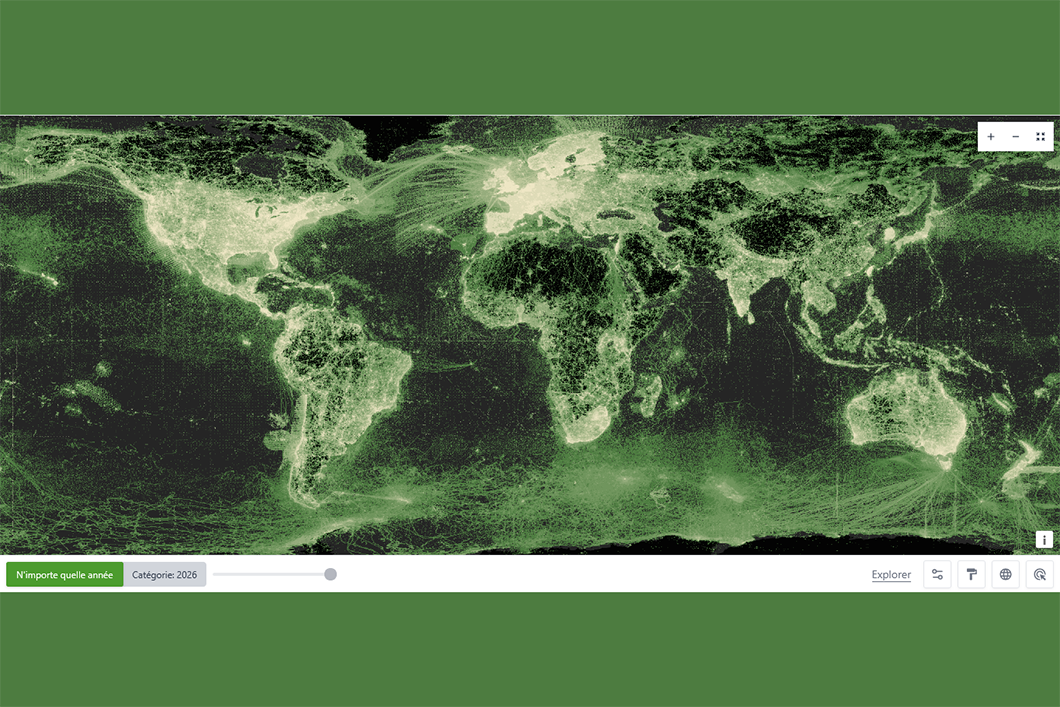
By actively contributing to the dramatisation and scientific representation of the world, these visuals create the illusion of providing exhaustive knowledge of our planet. The very notion of blank spaces on maps seems to have been banished. In fact, the datasphere is far from being uniformly distributed across the globe. Geodigitalisation (the process of converting the world into data) remains very uneven geographically. In this sense, the visual presentation provided by the Global Biodiversity Information Facility (GBIF, an international organisation that centralises biodiversity data) serves as a prime example. By bringing together 3.5 billion geolocated observations of fauna and flora, it conveys the illegible image of a deluge of data.
OpenStreetMap contributors (c) OpenMapFiles GBIF

7
Slideshow mode
An examination of the geographical distribution of biodiversity observation spots identified by the Global Biodiversity Information Facility (GBIF) reveals an uneven collection of information. Only 10% of the records are located in the intertropical belt, even though most of the world's biodiversity is concentrated in the region. As can be seen on this histogram (with degrees of latitude shown on the vertical axis, and the number of biodiversity observation spots on the horizontal axis), many urban areas in Western Europe and North America alone account for several million observations. By changing scale and moving from a global analysis to a local one, the Spherographia team highlights these disparities and explores their political implications.
OpenStreetMap contributors (c) OpenMapFiles GBIF

8
Slideshow mode
Globes have now become the preferred form of a comprehensive representation of the world and are reviving the positivist approach to cartography. However, although there is only one Earth, there is not just one but a multitude of worlds – and almost as many globes attempting to represent them, challenging the graphic representation of a hegemonic view of our planet. The democratisation of cartographic tools means that maps and globes, whether virtual or not, are no longer the exclusive preserve of mapping experts. Scientists, activists and artists are increasingly producing counter-maps and globes that provide alternative representations of the world. The now famous work “America Invertida”, created by the Uruguayan artist Joaquín Torres García in 1943, thus argues that “our” North is the South.
Joaquín Torres García (1878–1949) - América Invertida- 1943, Musée National des arts visuels, Uruguay

9
Slideshow mode
Since the turn of the century, indigenous peoples have been particularly active in counter-mapping in support of their territorial claims, in the face of colonial maps that ignore their existence. Despite these efforts, the publication of these maps is obstructed in many countries. Yet the presence of these populations is attested in at least 90 countries, and it is believed to number some 500 million, representing 6% of humanity. The Spherographia collective proposes an exercise in extrapolating current – albeit partial – knowledge of the location of the territories occupied by these peoples to the entire planet in order to reveal what a globe of indigenous lands might look like. This alternative globe is an invitation to imagine another world, in which indigenous peoples are arbitrarily placed on what are considered to be “virgin” territories. ––– EXPLORE THIS GLOBE IN AUGMENTED REALITY: Scan the QR Code with your phone's camera, then point it at the marker just below it.
Fabrice Dubertret, 2026
À propos
Spherographia [19] is an arts-science project funded by the French National Research Agency (ANR). It brings together researchers from six research units with diverse disciplinary approaches, artists' collectives and partner museums.
Explore more
Society

Article
10/23/2026
Article
10/15/2026

Article
10/12/2026

Article
10/05/2026
Article
09/14/2026
Cartography
Article
10/21/2020
Digital data
Article
09/26/2023
Opinion
10/26/2015
Keywords
Digital data [28] Earth [29] Mapping [30] Map [31] Apollo 17 [32] Planet [33] Google Earth [34] World [35] Cartography [36] Indigenous Peoples [37]